
Attribute information products
Attribute information products provide tabular information for use with mapping and Geographic Information System (GIS) applications.
What's new?

GeoSuite
GeoSuite is a tool used for data retrieval, query and tabular output. It allows users to explore the links between all standard levels of geography and to identify geographic codes, names, unique identifiers, and, where applicable, types, as well as land area and population and dwelling counts.
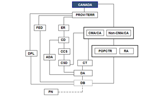
Geographic Attribute File
The Geographic Attribute File contains geographic data at the dissemination block level. The file includes geographic codes, land area, population and dwelling counts, names, unique identifiers, DGUIDs and types, where applicable.
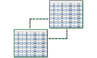
Correspondence files
The correspondence files contain unique identifiers for the current and previous census dissemination blocks and dissemination areas.
- Date modified: